
Webb County ZIP Code Coverage
The following postal inventory is a working list from Webb County and Laredo-area research. It is not a definitive boundary table. USPS is the authority for a particular street address, and the postal city returned by USPS does not decide incorporated-city status. Exact station names were not located in the official source set, so the post-office column records only the supported postal-service lead. Check the full address before treating any row as a delivery, city, or jurisdiction answer.
| ZIP | Areas Covered | Post Office | Notes |
|---|---|---|---|
| 78040 | Laredo-area lead | Laredo postal service; exact station not located | Confirm the address and city limit separately. |
| 78041 | Laredo-area lead | Laredo postal service; exact station not located | A postal city label is not municipal-boundary proof. |
| 78042 | Laredo-area lead | Laredo postal service; exact station not located | May occur in PO-box or delivery contexts; verify by address. |
| 78043 | Laredo or Rio Bravo area lead | Laredo postal service; exact station not located | Official postal-label material associates Laredo delivery; confirm the exact address. |
| 78044 | Laredo-area lead | Laredo postal service; exact station not located | Delivery or PO-box context needs address-level confirmation. |
| 78045 | Laredo-area lead | Laredo postal service; exact station not located | Not a city-limit boundary. |
| 78046 | Laredo-area lead | Laredo postal service; exact station not located | Postal-label material has a Laredo delivery association; verify address. |
| 78049 | Laredo-area lead | Exact station not located | May be specialized or unique; do not infer population or household coverage. |
| 78344 | Bruni postal lead | Bruni postal service; exact station not located | Webb CISD tax material shows Bruni; USPS still controls the address answer. |
| 78369 | Mirando City postal lead | Mirando City postal service; exact station not located | Check the USPS city label and civic jurisdiction separately. |
| 78371 | Oilton postal lead | Oilton postal service; exact station not located | Confirm whether the address is PO box, route, or standard delivery. |
None of these entries says that every address in the postal city lies in the incorporated city. The research did not locate a complete official city-by-ZIP result for every row, a ZIP split date, or an official per-ZIP population or voter table. Treat the inventory as a research lead until USPS returns a result for the actual address.
USPS Postal Results for Webb County
USPS ZIP Lookup has three different modes: By Address, By City and State, and Cities by ZIP Code. By Address requires a street address and allows a company entry as optional information. Use that mode when delivery is the question. USPS expressly warns that its result does not confirm a person or company at an address. It also warns that ZIP boundaries do not necessarily follow city boundaries.
Write down the address used, the returned ZIP and city label, and the date checked. If a street number is uncertain, use the official city-and-state or ZIP-to-cities mode only as a lead, then return to the full address. That discipline prevents a broad postal label from being treated as proof about a parcel, municipality, or household.
| By Address | Use a complete street address for the authoritative postal assignment. |
|---|---|
| By City and State | Use as a place-name lead, not a boundary conclusion. |
| Cities by ZIP Code | Check postal labels associated with a ZIP, then confirm the specific address. |
Webb County ZIP Address Fields
Webb County tax instructions describe address, owner, and account alternatives, not a verified ZIP filter. When an exact address has been normalized through USPS, the tax search can be used to check a property record. A result can provide an account number, owner label, situs and mailing address, tax year, payment or delinquency information, taxing entities, value, exemption, and bill or receipt links. Keep the situs and mailing fields distinct. Neither one proves who is currently present at the location.
The Webb CISD ACT tax portal shows the supported property-search routes.
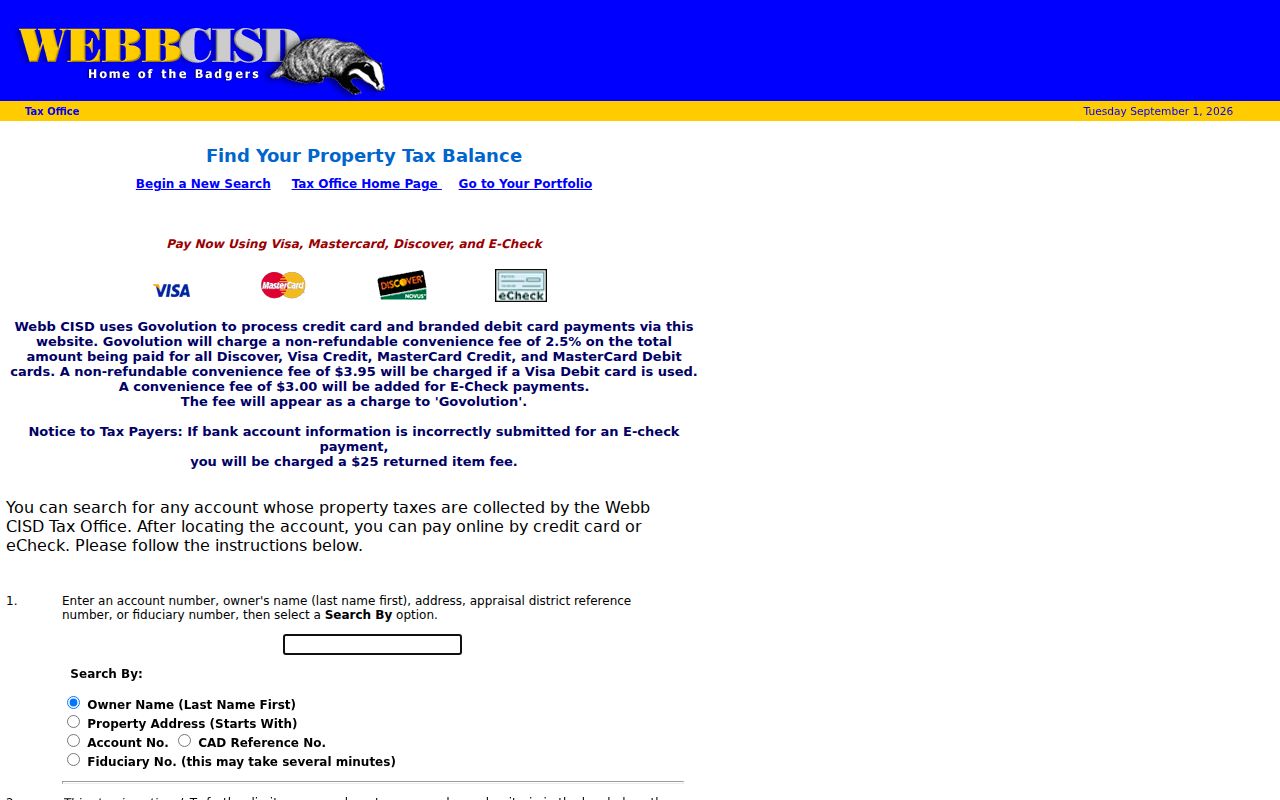
The image is useful for seeing address starts-with, owner, account, CAD reference, and fiduciary options. It does not show a documented ZIP field. Search an exact, USPS-confirmed property address instead of assuming that a ZIP-wide query is available.
| Field | Input | Use | ZIP Code Note |
|---|---|---|---|
| Property address | Starts-with street address | Find an address-based tax lead | Normalize through USPS first. |
| Owner name | Last name then first name | Find an indexed owner label | Not a ZIP filter or occupancy finding. |
| Account number | Exact account identifier | Open a known tax account | Keep it separate from postal data. |
| CAD reference | Property reference | Cross-check appraisal-related information | Verify any address against the source record. |
Webb County ZIP Systems Compared
Postal, census, municipal, and property systems organize geography for different purposes. USPS assigns delivery information. The Census uses ZIP Code Tabulation Areas, or ZCTAs, as generalized statistical geography rather than USPS delivery routes. County GIS and City OpenGIS show city limits, ETJ, precincts, roads, flood studies, annexation tracts, zoning, and other civic layers. A recorded plat, tax record, or deed provides a property-specific legal-description trail.
| System | Best Question | What It Does Not Settle |
|---|---|---|
| USPS ZIP Lookup | Which ZIP and postal label apply to one address? | Whether a person or company is there, or the civic boundary. |
| Census ZCTA | What statistical geography approximates a ZIP? | A USPS route or municipal boundary. |
| County or City map | Which civic boundary or ETJ layer applies? | A survey-grade property conclusion. |
| Tax, CAD, or deed | Which record describes the parcel or filing? | A universal ZIP or occupancy conclusion. |
County map products are described as general information rather than material for specific applications. For a boundary-sensitive issue, reconcile the map with a recorded plat, deed, survey, or current official confirmation.
Use a Webb County ZIP Code
A ZIP is best used as a starting point for an address-specific trail. It can be entered in Texas MVP's name mode as an identity filter, but it does not establish a civic boundary or occupancy. Webb Tax instructions document property address, street name, owner, and account alternatives without a ZIP filter. Webb CISD ACT documents address starts-with, owner, account, CAD reference, and fiduciary fields, also without a ZIP field. County and City maps use civic layers rather than a ZIP search.
- Run the full street address through USPS and save the returned postal ZIP and city label.
- Compare city limits, ETJ, precinct, or incorporated-place layers using County GIS or City OpenGIS.
- Search the tax or appraisal route with the confirmed address, owner name, account, or CAD reference that the portal actually accepts.
- Use a record-specific custodian when the question concerns a deed, case, election status, or city service.
Once an address is confirmed, the Streets section handles the address-level record trail. Do not substitute the postal code for a street, lot, block, or legal description.
Note: The research found no verified tax portal with a ZIP filter, so a ZIP-wide result should never be implied.
Laredo Postal Labels and City Limits
Laredo is the county seat and largest urban center, but a Laredo postal label can reach beyond incorporated Laredo. Rio Bravo and El Cenizo are incorporated places near the Laredo area. Bruni, Mirando, and Oilton are smaller incorporated communities identified in county election material. City limits, the five-mile ETJ, school districts, voting and Justice of the Peace precincts, drainage districts, and flood areas follow their own map layers.
That difference is especially important for a Bruni, Mirando City, or Oilton address. Use USPS for delivery, then compare the county incorporated-place or precinct map, the tax record, and the agency with jurisdiction over the requested record. A Laredo-style postal label cannot replace that comparison. No public searchable neighborhood-association directory or official neighborhood-level address database was located in the research.
Webb County ZIP Code Terms
Postal terms help explain why a code is not a person or place finding. Use them as labels for the system that produced the result, rather than as evidence about a household.
- ZIP and ZIP+4
- A ZIP identifies the main postal area. ZIP+4 is the additional delivery detail returned for a specific address; neither is a municipal boundary.
- PO-box ZIP
- A postal code used with box service or a delivery context. It should not be used to infer the recipient's physical location.
- Unique ZIP
- A specialized postal assignment. The research flags 78049 only as a possibility, not as a confirmed designation.
- Carrier route
- A postal delivery grouping. It is not a resident list, a civic district, or a parcel boundary.
- ZCTA
- A Census statistical approximation of ZIP geography, not the USPS delivery route.
Document a Webb County ZIP Code
A careful postal research note keeps labels separate. Record the exact address submitted to USPS, the returned ZIP and postal city, the check date, and the map layer used for city or ETJ review. Then record the tax, CAD, or deed field by its own name, such as situs address, mailing address, account, legal description, or instrument number. This makes later review possible when two systems use different labels.
For voter work, Texas MVP's name mode includes ZIP among its official inputs, but its result and protected information remain subject to election rules. Do not convert ZCTA totals into USPS ZIP totals or use any postal result to assert a roster of people. The research located no official per-ZIP Webb County voter or population table.
Webb County ZIP Code Limits
The postal directory has firm limits. USPS confirms address delivery information, not a person or company at the address. ZCTAs are not municipal boundaries. A tax mailing address, exemption, deed hit, or property-owner label does not prove occupancy. County and city maps may guide a jurisdiction check but are not substitutes for a survey, plat, deed, or current official confirmation.
Use only supported conclusions. Keep postal, civic, and property facts separate, and do not use a ZIP code to identify or expose a protected person, household, or address.
No official historical ZIP split or realignment record for Webb County was located. When an address has changed labels over time, document the source and date instead of guessing which modern ZIP or city name applied in the past.